DeepWeeds edge classifier
Rangeland weed classifier taken all the way to silicon: 96% top-1 at 2,200 FPS on a Raspberry Pi 5 with a Hailo-8 NPU, within a point of the FP32 baseline, after an INT8 quantisation study that forced a change of backbone.
Edge AI · Aerial autonomy · Brisbane
Software engineer in Brisbane, Australia. MPhil in aerial robotics at QUT Centre for Robotics, thesis under examination, after 16 years of shipping software, 12 of them on mobile.
About
My work sits where computer vision meets flight hardware. I train detectors on aerial imagery, quantise them to run on a small NPU at the edge, and fly them on PX4 and ArduPilot airframes, including the fixed-wing and multirotor UAVs I print and build myself. My MPhil asked a practical question: when should a UAV search from high altitude and verify low, and what does that trade-off cost in mission time? The answer became a decision framework, a simulation and a published paper.
Before robotics I spent twelve years in commercial mobile development, ending as Principal Software Engineer and iOS Development Lead at CBRE Asia Pacific, where I led a 65-app suite and its release pipeline. I hold a Bachelor of Information Technology (First Class Honours) from QUT and a CASA Remote Pilot Licence to 25 kg.
More on GitHub
Selected work
Rangeland weed classifier taken all the way to silicon: 96% top-1 at 2,200 FPS on a Raspberry Pi 5 with a Hailo-8 NPU, within a point of the FP32 baseline, after an INT8 quantisation study that forced a change of backbone.

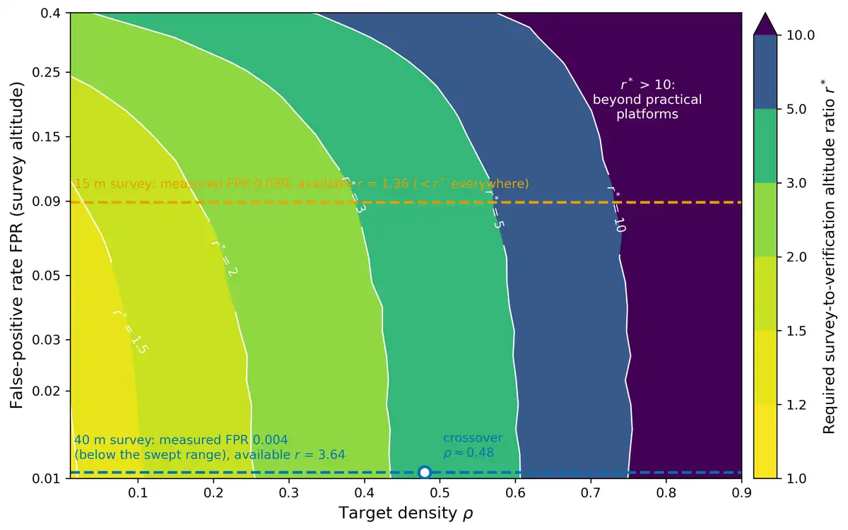
The Monte Carlo model behind the Remote Sensing paper. Measured detector recall and false-positive rates go in, a decision table for survey altitude comes out.
Publications

Remote Sensing 18(18), 3129, 2026
Surveying at 40 m and verifying detections at 11 m cuts total mission cost by 46% in sparse fields, with a 22% penalty in dense ones. The paper gives the break-even density and the decision table behind it.
Updates
Fly High or Fly Low? is out, open access, with Frederic Maire, Juan Sandino and Felipe Gonzalez.
Altitude and Density Trade-offs in High-Recall UAV Object Detection: A Quantitative Framework for Survey Strategy Selection, at QUT Centre for Robotics.
96% top-1 at 2,200 FPS on a Raspberry Pi 5, within a point of the FP32 baseline.
Contact
I'm open to collaborations and new projects across industry, research and government, especially around on-aircraft perception, survey planning and PX4 and ArduPilot systems.